
Hamilton’s legacy
Lisa Smedman
Van. Courier
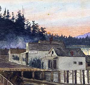
When surveyor Lauchlan Hamilton arrived in 1884, Vancouver was a tiny village, captured here in his painting. When he left four years later, it was a thriving city. (First in a monthly series on the names behind Vancouver streets.) Artwork L.A. Hamilton, City of Vancouver Archives documentary art 72-422-9
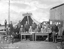
The mayor and alderman set up city hall in a tent after the great fire of 1886. Photo-Harry T. Divine courtesy City of Vancouver Archives LGN 1045
One hundred and twenty years ago, the man who would name most of the streets in downtown Vancouver stared at the street grid he’d just laid out and scratched his head, trying to come up with more names. He’d already named a number of the streets after B.C. politicians, Canadian Pacific Railway officials, and prominent businessmen like Vancouver Island coal baron Robert Dunsmuir. He’d also named two streets after Burrard Inlet’s original south-shore townships: Hastings and Granville. But with nearly two dozen more streets to name, he was running dry.
For inspiration, he broke out some Admiralty charts of the B.C. coast. Place names jumped out at him-names of islands, lakes, inlets, channels and straits. All became fodder for street names, albeit with a couple of misspellings.
To cap it off, he named one street after himself-the very first street he’d surveyed in 1885: Hamilton Street.
Lauchlan Alexander Hamilton only lived in Vancouver for four years, but he had a tremendous impact on the shaping of this city. Sent out by the CPR to survey the property the railway had been granted in return for relocating the terminus of its national line from Port Moody to Coal Harbour, Hamilton sat as an alderman on the first city council and helped create Stanley Park. An accomplished watercolour painter and photographer, he captured some of the earliest views of the city.
Continued from page 1
His years here were filled with tragedy, as well as triumph. He barely survived the fire that wiped out Vancouver in 1886, buried his first wife later that year, carried on as a single father, and nearly drowned in a canoe accident near Stanley Park.
By the time Hamilton was transferred by the CPR to Winnipeg in 1888, Vancouver had grown to a population of nearly 10,000. It had three-storey brick buildings, electric street lights, sewers in the business section of the city, and a local telephone system with 150 subscribers and a connection to New Westminster. The Capilano Water Works company was laying a cast-iron pipeline from the North Shore across First Narrows; the water was scheduled to be turned on in April 1889. Homes, businesses and shops were illuminated by either electric or gas light.
The city had a hospital, two schools, three banks and six churches, and the CPR had built an impressive hotel. The main industry was still lumber-Vancouver boasted six sawmills-but other industries were cropping up, including a foundry and lime mill.
All this was a far cry from the rough sawmill town, population 300, that Hamilton came to in 1884.
Hamilton, a third-generation Canadian, was born in Penetanguishene, Ontario on Sept. 20, 1852. After apprenticing as a surveyor, he took part in the survey that plotted the 49th parallel through the Prairies between 1872 and 1874, establishing the international boundary between Canada and the U.S.
When the Canadian Pacific Railway was incorporated in 1881, Hamilton became a CPR land commissioner. As the railway moved west across the country, Hamilton was one step ahead of it, surveying townsites along the route and plotting where their streets would go. Regina, Moose Jaw, Medicine Hat and Calgary were all his creations.
The CPR originally picked Port Moody as the terminal city for its cross-country railway. But in 1884, the CPR negotiated with the provincial government for land near Coal Harbour, in return for relocating the terminal there. This, it was hoped, would spur sales of government land near Burrard Inlet and False Creek.
In February 1885, it was officially announced that a spot just west of Granville Townsite would be the end of the line. The town to be created there would be named Vancouver-a name suggested by CPR president William Van Horne.
The CPR was granted a huge chunk of land-6,458 acres in total. On a modern map, this land grant would cover the eastern half of downtown-everything between Burrard and Carrall streets (excluding the original Granville Townsite). South of False Creek, the land given to the CPR stretched from Trafalgar Street in the west to Ontario Street in the east, and south from False Creek to about 57th Avenue.
Although settlers had been pre-empting land around Burrard Inlet since 1860, the first “town” didn’t spring up until 1870, when Granville Townsite was laid out. Today known as Gastown, it lay just west of Hastings Sawmill (which began operations in 1865 as Stamp’s Mill).
The town wasn’t much to look at. A map of the township published in August 1885 shows only four streets, each little more than a block long. The mapmakers gave these streets arbitrary names: Front (now Water Street), Willow (now Cordova Street), Water (now Carrall Street), Wood (now Abbott Street). The map shows three hotels-Sunnyside Hotel, Granville Hotel, and “Gassy Jack’s” Deighton Hotel-as well as a dozen smaller buildings including shops, a meat packing plant, boarding houses, cow barn, real estate office and Chinese wash house.
W.H. Gallagher, whose memories of early Vancouver were recorded in 1931, recalled what the settlement looked like in 1885. Granville, he said, was a rough clearing along the shore about two blocks long (between the modern streets of Cambie and Carrall). It was “boxed in by tall trees, damp, wet, the actual clearing littered with stumps and forest debris, and a profusion of undergrowth including luxuriant skunk cabbage. A great wall of trees stood along Hastings Street and faced the waterfront; two similar walls flanked the clearing [on the east and west]… All else was verdant woods.”
Several of the buildings were built on piles over the water. The streets were either dirt or wooden skid roads. European women were scarce, and saloons did a brisk business serving loggers. The Granville Hotel offered “eye opener” drinks with breakfast. A single drink cost 10 cents, but they were cheaper by the half-dozen-just 25 cents.
Hastings Mill, with 75 employees-“whites, Chinese and Indians”-produced an “incessant rattle of machinery and cloud of escaping steam,” according to the B.C. Directory of 1882-’83. From the Moodyville Sawmill, across the inlet in what would eventually become North Vancouver, came “the buzz of saws, the hum of innumerable drums and pulleys, and the noise of shifting lumber as it sweeps down the inclines through the ports of the different ships.”
Stage coaches connected Granville with New Westminster. Steam ferries offered service to Moodyville (North Vancouver) and Port Moody.
Hamilton began surveying the CPR’s townsite in the spring of 1885. According to a story published in 1953 by the Vancouver City Archives, he set out one day from the Sunnyside Hotel on Water Street accompanied by an eight-man survey team that included Hamilton’s brother-in-law, John Leask. Hamilton drove a stake into the earth “with a certain amount of ceremony” at what would one day be the corner of Hastings and Hamilton streets. Then he set out to impose straight lines on a logged-over forest.
Axemen chopped sight lines through the woods, and then it was the turn of the men with the surveying instruments. Under Hamilton’s supervision they worked with a transit (a device that looks like a telescope mounted on top of a large compass, supported by a tripod), rods, levels and the surveyor’s equivalent of the tape measure: a 66-foot-long chain.
That first day had its mishaps-Leask got lost in the woods and the crew spent the afternoon searching for him. But over the course of that year, Hamilton plotted out a street grid and surveyed lots, filling his field survey notebooks with notations like “cedar swamp,” “heavy fir” and “good timber.”
Then the heavy work of carving streets through the forest and clearing lots began.
As the CPR’s land commissioner for Vancouver, it was Hamilton’s job to hire the crews and oversee their work. Streets were supposed to be 66 feet wide-one chain-and crowned to allow for water runoff, but when Granville Street was first laid out it was simply rough graded to about 12 feet wide. There were stumps on either side where drainage ditches should have been. Eventually, Granville was surfaced with thick wooden planks. It was a “passable road,” even if it wasn’t pretty.
To clear the lots, crews felled and “limbed” trees by sawing off branches. The resulting stumps were blasted out. The logs themselves were fodder for the mills, but the rest of the slash was burned where it had fallen.
The CPR began selling lots in its new township on May 5, 1886, just a month after Vancouver was formally incorporated. It would be a year before the first transcontinental train would arrive, but the properties sold briskly. The lots had cost $300 per acre to clear-well above the $15 to $20 per acre the CPR had expected to pay-but the profits were spectacular. The CPR made a bundle, and so did land speculators.
Donald Alexander Matheson was one of those hired to clear the CPR lands. He came to Vancouver in 1885 as a teenager. He convinced Hamilton to give him a job supervising a work crew.
“L.A. Hamilton was a regular father to me,” recalled Matheson in 1940. He would say to me, ‘Dan, you had better buy some property,’ and he would tell me where to buy; where were the best lots.”
Hamilton‘s advice: purchase a property, make the first payment, wait 12 to 15 months, then sell. Matheson did, selling one lot he’d purchased for $1,000 for twice the price just a year later. This, at a time when the average daily wage for labourers was $1.25 to $1.50 per day.
By the summer of 1886, Vancouver was a city of several hundred buildings. More were going up every day. But then, one Sunday in June, disaster struck. In a single afternoon, the entire city burned.
That summer, Hamilton was working out of the CPR office at the corner of Carrall and Abbott streets that had been erected about six months previously. When he heard that a fire had gotten away from a land-clearing crew and was racing east towards the town, he ran to his office to collect as many documents as he could.
Hamilton‘s brother-in-law, W.E. Bodington, related the story: “Suddenly he discovered he was in the midst of the fire. He put the sheaf of papers under his arm and ran into the street, into a very cauldron of fire. He rushed down the street [probably Alexander Street] telling the man with him to follow him closely. Breathing air as hot as cinders they got safely to the Sunnyside [Hotel] and got out on the water.”
Looking down, Hamilton found the papers he’d worked so hard to rescue had been charred by the fire and were ruined. He also lost a number of the photographs he’d taken, which were destroyed along with the CPR office.
Another story has Hamilton running from the fire with his survey instruments under his arms, only to look down later and find that the glass in those instruments had been cracked by the heat of the fire.
The next day, the settlers began building their city again.
Hamilton, by then a city alderman, chaired the committee that coordinated relief for victims of the fire. Later, he was credited with painting the words “city hall” on a board that was nailed up over a tent where the city’s mayor and aldermen met after the fire. A photo, purportedly taken just days after the fire but actually staged months afterward, shows Hamilton seated at a makeshift council table outside the tent.
One of the first projects Hamilton tackled as an alderman was to negotiate with the federal government for a government naval reserve to be turned into a city park-today’s Stanley Park. Hamilton surveyed the first road around the park and oversaw its construction.
During one of his inspection trips of this work, Hamilton and one of his engineers suffered a near-fatal mishap.
“[We] nearly drowned by having our canoe upset in the Narrows in a tide rip,” Hamilton later wrote in a letter to the city archives. “We both had a hard struggle to get the canoe ashore. Then, in our wet clothes on a bitterly cold evening, [we] paddled all the way back to the Granville wharf.”
Hamilton went on to serve a second one-year term as alderman in 1887. During the city’s second election, he received more votes than any other alderman.
Hamilton never lived on the street that he gave his name to. When he left Vancouver in 1888, Hamilton Street was still being cleared, and only had a handful of buildings. Residential lots, back then, were selling for anywhere from $200 to $2,000.
When the 1890 R.T. Williams City Directory was published, Hamilton Street was only four blocks long. It ended at Robson, where the bush began. Entirely residential aside from First Baptist Church on the southeast corner of Hamilton and Dunsmuir, it still contained a number of vacant lots.
Those who had built homes on Hamilton Street by 1890 included a cross section of Vancouverites. John McLagan, publisher of the Vancouver Daily World newspaper, lived in the 300 block. So did Charles Carter, owner of Carter’s Temple of Music. Others who’d built homes on Hamilton included two carpenters, two tailors, an accountant, a dry goods store owner, a grocer, a CPR mail clerk, a real estate agent, a butcher, a ship builder, a shingle mill employee and a “cigar agent.”
By 1895, Hamilton Street had been pushed through to Smithe. By 1900, to Nelson. The first institutional buildings started to appear. Central School, an eight-room red-brick building across the street from what is Victory Square today, was built in 1889.
Commercial buildings included the three-storey Inns of Court at Hastings Street, which by 1905 provided office space for realtors, barristers, bookkeepers, architects, dentists, contractors, financial brokers, the consul from Ecuador and the American Mandolin School and Novelty Company.
By the 1910s, the northern end of Hamilton Street was solidly commercial, lined with stores, wholesalers and apartments offering furnished rooms. To the south, Hamilton was pushed through to Davie Street, where the warehouse district became entrenched. Wholesalers, importers, factories, storage companies, grocers and a foundry were in place there by 1915.
A drive down Hamilton Street from south to north today offers a trip back in time. From Drake to Nelson streets, modern condos, cafes, hair salons and urban-chic decor outlets have taken root in the renovated brick shells of former warehouses. Shops cater to the tastes of the urban elite who slurp oysters and smoke cigars-pleasures that were also popular in Hamilton’s day.
At Nelson, the street becomes a construction zone where three unfinished cement-and-glass apartment towers-two of them already more than 30 storeys tall-block the view. Just one block north are four single-family homes, the sole survivors of the types of houses that used to line Hamilton. Three are original Queen Anne style homes, built in 1893. The fourth is an exact replica of a house that was built in 1895.
A host of institutional buildings fill the blocks that follow: the main post office and Queen Elizabeth Theatre, both built in the late 1950s; the CBC building, opened in 1976; and the Central Branch of the Vancouver Public Library, opened in 1995.
The old stone building at 505 Hamilton, on the southwest corner of Pender and Hamilton, dates to 1906. It originally was home to the International Order of Oddfellows Hall.
Victory Square, the site of Vancouver’s first courthouse, was created in 1924 when the cenotaph was unveiled.
The most northern block of Hamilton, the 400-block, is paved in cobblestones that were probably installed between 1907 and 1912. The curbs are granite-used because it could resist scuffing by iron-banded wagon wheels.
Hamilton ends at Hastings Street, at the 13-storey Dominion Building with its rounded roof and solid red columns, built in 1910. Next door are the Amsterdam Cafe and Marijuana Party book store.
In addition to laying out the streets of downtown Vancouver, Hamilton surveyed the CPR property south of False Creek. He liked to camp there; photos taken in 1886 show him canoeing and tenting on False Creek with his first wife, Isabella (whose name is also recorded as Isobel and Isabel) and their daughter Isobel, then about five years old. Their campsite was near the current location of Granville Street and Sixth Avenue. Hamilton named the area Fairview after the view his campsite offered of False Creek.
Hamilton had only three weeks to survey the area; he worked, he later recalled, “night and day” to get the job done. Decades later, in 1936, Hamilton wrote to Vancouver archivist Major J.S. Matthews about the inspiration for the street names in that area.
“I had a free hand in the property lying south of False Creek, so there I was able to adopt the modern system of naming the avenues First, Second, Third, etc., and the streets I called after trees…”
Hamilton had intended the tree-named streets to be arranged alphabetically, but a draftsman’s error resulted in the existing configuration being registered at the Land Registry.
According to one story, Hamilton got the idea to name streets after trees from an existing street name. Heather Street was named by Scotsman William Mackie, who had pre-empted land in the area.
Around the time Hamilton was laying out Fairview, his first wife died.
A death certificate was filed in New Westminster for Isabella Easton Hamilton, who died on Nov. 13, 1886 at the age of 27 from tuberculosis. It is unclear whether this is L.A. Hamilton’s wife, since the signature of the next of kin who confirmed identity of the body is illegible.
Hamilton remarried two years later. His second wife was Constance Bodington, who had been born in England and who came with her parents to Vancouver in 1887. Her father, George Bodington, was said to have been Vancouver’s first doctor.
The marriage was held on April 10, 1888 at St. James Church. Harry Abbott, superintendent of the CPR, loaned the couple his private railway coach for their honeymoon trip to Harrison Hot Springs.
Shortly afterward, Hamilton was transferred by the CPR to Winnipeg to replace that city’s land commissioner, who had died.
Hamilton and his family lived in that city for 13 years before he retired and moved to Ontario.
Although Hamilton was gone from Vancouver, he wasn’t forgotten. In 1938, Vancouver’s council honoured Hamilton by granting him the freedom of the city. Hamilton was too sick to travel to Vancouver to collect the honour, which had to be bestowed at his winter residence in Florida. In his thank you speech, he recalled Vancouver as being “an insignificant village on the sea shore” when he first set eyes on it.
Hamilton died on Feb. 11, 1941 in Toronto at the age of 88. More than a decade later, Vancouver was still paying him tribute. In 1953, his daughter Isobel-Hamilton’s only child, who never married-came to the city to unveil a plaque in her father’s memory.
The memorial can still be seen on the old Bank of Commerce building-now vacant-on the southwest corner of Hastings and Hamilton streets. Although green with verdigris, its inscription is still sharp.
It reads: “Here stood Hamilton, first land commissioner, Canadian Pacific Railway, 1885. In the silent solitude of the primeval forest he drove a wooden stake in the earth and commenced to measure an empty land into the streets of Vancouver.”