
Municipality won’t suffer same fate as New Orleans, city official says
Darah Hansen
Sun
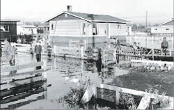
CITY OF RICHMOND ARCHIVES Flooding in Richmond, 1954
Richmond is in the process of pumping millions of dollars into upgrading its perimeter diking system to keep the city — large portions of which sit below sea level — from suffering the same fate as New Orleans.
Eighty-three per cent of New Orleans was under water this week after its levee and dike system around Lake Pontchartrain failed in the wake of Hurricane Katrina.
That won’t happen in Richmond, despite its own reliance on dikes to keep the water out, said Dave Semple, city manager of public works.
“We’re constantly, with the staff, monitoring the dikes to ensure they are safe,” he said.
According to Semple, Richmond will begin a program in November to raise and reinforce older sections of the dike considered to be most vulnerable to flood waters from the surrounding Fraser River. That work will be done in conjunction with development along River Road, including the soon-to-be-constructed Olympic Oval.
“We’re in the process right now of trying to determine how high to rebuild that [portion of the] dike,” Semple said.
Semple said staff in his department have been watching with keen interest the television images of the flood disaster as it unfolds along the U.S. Gulf Coast, hoping to pick up some tips on how to avoid a similar situation locally.
“This one is pretty interesting,” Semple said of the unexpected fallout from the floods, including alarming scenes of looting and violence, mass electrical blackouts and a general lack of potable water.
“The blessing is, we don’t have any graveyards below sea level,” he said.
Semple said the likelihood of Richmond‘s perimeter dike system being topped by flood waters is highly improbable.
Richmond‘s dikes have been designed to a standard that will theoretically withstand the kind of storm that comes around only once in 200 years. The last time that happened was in 1894, when a spring freshet (or high river discharge) sent water surging over the dike along the city’s northern sector. Roads were washed out and crops ruined.
Even so, Richmond suffered less than other Lower Mainland municipalities farther up the Fraser. That’s because Richmond boasts a certain luxury of location: the Strait of Georgia at the city’s western edge provides a handy valve for even the highest river flow.
“Basically for Richmond to be overtopped, you literally have to fill up the gulf,” Eric Gilfillan, retired public works manager, told the Richmond News in an interview last year.
Using computer animation, city staff have mapped out several flood scenarios should Richmond‘s perimeter dike system fail. In the worst-case scenario, a breach along the city’s east end would cause the most serious damage, sending water running downhill to the southern tip of the island. But, unlike the situation in New Orleans, waters flooding Richmond would be subject to the tides. At high tide, flood waters would pool across the city, but dissipate when the tide goes back out.
In New Orleans, Semple said, the situation is more difficult — and expensive. Repairs must first be made to the damaged lake levee, and then the water has to be pumped back where it came from.
According to Semple, heavy rains in November through February pose the biggest flood threat to Richmond. Pumping stations set up at various locations along the city’s waterfront work around the clock pumping rain water out of ditches and collection systems and into the Strait of Georgia.
HARD AT WORK TO KEEP THE WATER OUT:
If there were no dikes around Richmond — one of only a handful of fully diked cities in North America — the island city would be under water for eight to 10 hours a day, depending on the tides.
Initially, the dikes were handbuilt by farmers and early settlers looking to protect their land and property from seasonal floods in the spring and fall. They have changed, however, as the city has changed: growing higher, sturdier and ever more able to keep out the waters of the Fraser River.
– The City of Richmond spends about $250,000 annually in maintenance and small repairs on its dike system.
– Richmond‘s dikes have been designed to a standard that will theoretically withstand the kind of storm that occurs only once in 200 years.
– Richmond‘s storm system and pump stations are built to withstand a severe rainstorm, the kind anticipated once every 10 years on the West Coast. Heavy rains in the fall of 2003 came close to testing that standard. Ditches were ready to overflow after 48 hours of rain, filling the system to capacity. But the rains eased off just in time, allowing pumping stations to do their job.
– A breach in the dike near the neighbourhood of Hamilton in the city’s east side would create the most serious flood damage. If left unchecked, flood waters would flow downhill, swamping the entire city during high tide.
– Richmond‘s Flood Protection and Management Strategy identifies a pipe break as the island’s most immediate flood threat. Freshets (high river discharge), extreme sea levels, a lowering of the ground, earthquakes or a gradual rise in sea level rise due to global warming are also noted as possible threats, according to the strategy.
– According to the Flood Protection and Management Strategy, improvements estimated to cost $90 million are needed to a 48-kilometre stretch of dike.
– Richmond is currently considering building interior dikes along either No. 7 or No. 8 Roads, or a concrete floodwall barrier along Highway 99/Knight Street to help prevent flood damage should a serious dike breach occur. Costs associated with the projects range from $15 million to $20 million each, plus the price of property acquisition.
© The Vancouver Sun 2005